
Walk a Sayreville Street by Address
For a street-by-street search, begin with one complete Sayreville address rather than a surname. The New Jersey Property Explorer connects the street address to a parcel, and the parcel supplies the block and lot used in local tax and recorded-document work. The assessed owner is a useful property fact, but it is not a roster of everyone at the address. Keep the situs, the physical parcel location, separate from a tax mailing address. Once the parcel is fixed, the same block and lot can be carried to a deed, permit, map, or a properly requested election-district list.
- Search the address in the Property Explorer with Middlesex County and Sayreville Borough selected. Save the situs, parcel identity, block, and lot.
- Open the same location in the GIS viewer. Pan along the street and identify adjoining parcels without treating map shapes as survey lines.
- Use the parcel details to check recorded documents by party, town, deed type, and date range in the Middlesex County browser.
- For a dated election question, identify the election district and use the County Clerk or Commissioner of Registration request route. The public status screen is not a street browser.
- For an older address snapshot, ask the library or archives for regional reverse-directory material and search the neighborhood and postal-name variants.
That order keeps each result in its proper lane. Parcel and deed records describe property and transactions. An election list is a dated registration record. A historical directory is a dated address clue. None should be stretched into a claim about every person connected to a street.
Search Sayreville Parcels by Street
The New Jersey property search and NJGIN documentation support searches by address, county, municipality, block, and lot. Start with the address, then try the municipality and county filters if a road name repeats elsewhere. Owner searching can help with a known person or entity, but spelling, initials, punctuation, and entity suffixes can change a result. State-hosted layers can also redact a protected owner name, so an empty name field is a prompt to verify with the assessor or County Clerk, not a reason to reconstruct protected information.
| Property Explorer field | Use for a Sayreville address |
|---|---|
| Street Address | Primary starting point; use a complete address and try USPS-style variants if needed. |
| Owner | Optional person or entity search; compare spelling and LLC variations. |
| County | Select Middlesex to narrow the search. |
| Municipality | Select Sayreville Borough to avoid same-street ambiguity. |
| Block / Lot / Qualifier | Use the tax identity for precise parcels, including some condominium or subdivision records. |
| ZIP | May appear as a field or filter; it is address geography, not a borough-boundary test. |
Sayreville's annual proof book includes owner and mailing information, property location, block and lot, class, values, exemptions, and a ZIP field. The state file is an annual January submission, so a later transfer may not appear there yet. Note: Compare a current assessor record with the County Clerk index when the timing of a transfer matters.
Use Sayreville GIS Along a Street
The NJGIN Statewide Property Explorer gives the street directory its geographic layer. Search an address or block and lot, then use the parcel click tool and pan controls to see the surrounding road segment. Available layers can include parcels, roads, imagery, zoning, flood areas, wetlands, open space, and municipal boundaries. The precise dynamic layer list can vary as the ArcGIS application loads.
A parcel polygon supports map browsing and tax context. It is not a legal survey boundary, and county parcel edges may not align perfectly at a county edge. For a boundary or title question, compare the map with the assessor record, the tax map, and a recorded legal description.
Sayreville Situs and Mailing Fields
Two addresses can appear on one Sayreville tax record. The property location, also called the situs, identifies the physical parcel. The owner mailing address tells the tax office where correspondence is sent. The official proof-book sample shows a Sayreville property with an owner mailing address in South River. That difference can reflect correspondence, not an address change or an occupant list.
- Parcel
- A tax-mapped unit of real property, commonly identified in New Jersey by municipality, block, lot, and sometimes a qualifier.
- Situs address
- The physical street location used to place a property on the ground.
- Plat
- A recorded map that can show lots, blocks, street layout, or a subdivision change.
- Criss-cross directory
- A reverse directory arranged from address to a dated occupant or business listing when that section exists.
This distinction is especially useful for family-history work. A deed or tax card may locate an owner while a dated directory provides a separate address clue. Record both fields exactly, including the postal city and ZIP, before treating them as related.
Trace Sayreville Deeds by Street
The Middlesex County Clerk's land-record chain supplies the strongest property trail behind a street address. The browser states online deed coverage from January 1, 1929, mortgage coverage from January 1, 1950, and other document coverage from January 1, 1958. A current deed party can be searched as a grantee, then the prior grantor can be followed backward. Grantor means the party transferring an interest; grantee means the party receiving it. Compare the legal description, block and lot, and instrument reference at every step.
See the Middlesex County Land Records Search landing page before starting a Sayreville deed search.
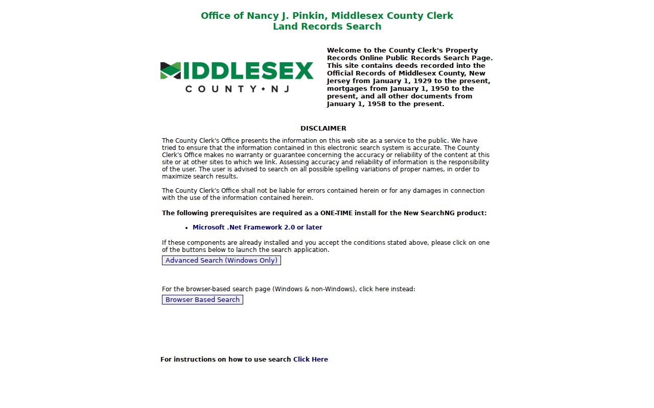
The landing page's coverage statement helps set the date range. For deeds before the online cutoff, use the Registry counter or written-copy route, then the State Archives for county deed microfilm through 1900 and FamilySearch digitization where available.
Search party-name variants and narrow the town to Sayreville, document type to deed, and the relevant date range. A mortgage, release, lien, easement, or tax-sale record can explain a title trail, but it is not itself an ownership transfer. Note: Preserve the instrument number and recording date with every deed result so later searches can be checked.
Search Sayreville Deed Browser Fields
The Middlesex Official Records browser offers more than a general party-name box. Use Party Name in last-name first-name form without commas, or switch to town, instrument, book and page, parcel, legal-description, map, or board and commission modes. In the town mode, Sayreville is a selectable Middlesex municipality. The interface identifies results as verified documents and exposes linked-document and page tools, while image access can involve the login or cart controls shown by the browser.
| Browser field | Street-search use |
|---|---|
| Party Name | Search a present owner or prior deed party, using spelling variants. |
| Town | Select Sayreville to limit a party or document search. |
| Document Type | Limit a title search to deeds; the portal also supports other document groups. |
| Date From / Date To | Use the portal's MM/DD/YYYY range to narrow a recorded period. |
| Lot / Block | Connect the tax parcel to a parcel-mode search. |
| Instrument Number | Open a known recorded document by its county reference. |
Open the official-records browser to compare the live modes and labels.
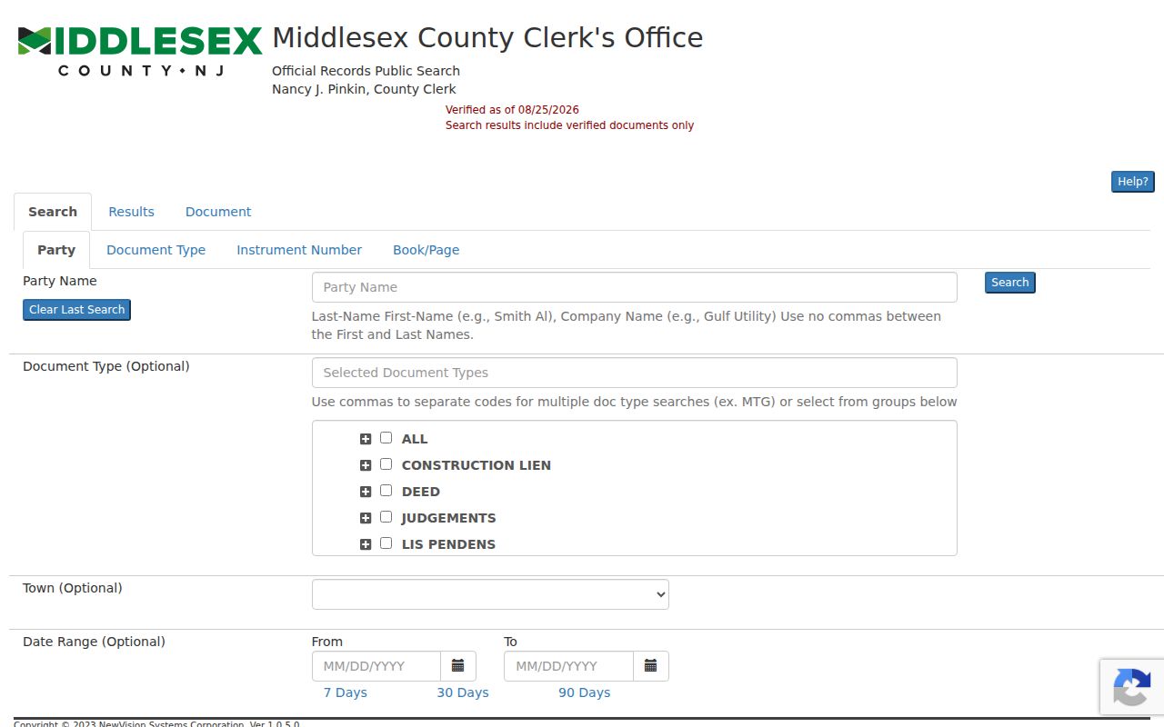
Record the document type, parties, recording date, consideration when shown, legal placement, and linked references before moving to the prior transaction. A street number can change while a legal description remains the steadier property link.
Sayreville Address Records by Street
Street records in Sayreville sit with different custodians, and each has a different scope. Use the parcel as the common reference. It links the assessor data to a deed's legal placement and makes an address-specific request more precise. The coverage below describes records that can be tied to a street; it does not turn them into a complete roll of people at an address.
| Address record | Custodian | Useful street detail | Access route |
|---|---|---|---|
| MOD-IV tax list | Sayreville Assessor, NJ Treasury, County Tax Board | Owner, mailing and situs fields, block/lot, class, values, exemptions, ZIP, tax-map page | Property Explorer, proof book, or assessor office |
| Parcel GIS | NJGIN and Middlesex GIS | Parcel geometry, PIN, nearby parcels, map layers | Web map and Open Data; not a survey |
| Recorded instruments | Middlesex County Clerk | Grantor/grantee, date, instrument, consideration, legal description, linked records | Browser index, counter, written request, or Archives for older work |
| Plats and subdivisions | County Clerk, Borough Planning/Zoning | Lot and block history, subdivision layout, street or lot creation | County maps or Borough OPRA request |
| Permit files | Sayreville Construction Department | Application parties, work, plans, inspections, and dates | FTG account, office, drop box, or OPRA |
| Code files | Sayreville Code Enforcement | Address-specific notices, complaints, and abatement status | Citizen portal for concerns; OPRA for existing files |
| Registry lists | Middlesex elections offices | Statutory election-district list fields and residence numbering | County request route; protected addresses omitted |
Start with the address and block and lot, then attach only the record that answers the question at hand. The Tax Collector, Construction Department, Code Enforcement, Borough Clerk, County Clerk, library, and State Archives all provide different fallbacks when a web result is incomplete.
Sayreville Permit Files by Address
The Sayreville Construction Department keeps address-keyed permit material. Its permit-status route uses an FTG account. For an existing file, the documented alternatives are the office or outside drop box at 49 Dolan Street, and a specific OPRA request. A permit file can include the property address, permit type, named applicant or owner, project description, plans, fee, inspection status, and availability or redactions. It documents work at a property, not a complete account of who was present there.
Code Enforcement maintains a separate address trail for property-maintenance and abatement matters. The public citizen portal is for submitting a concern, not a public case index. Request a bounded, existing address file under OPRA and read a notice with its disposition or abatement status. The Borough Clerk is the custodian for municipal records and OPRA requests, including records such as road-opening material, maps, and borough agreements that may explain an address or street change.
When a requested record is currently available, OPRA generally uses a seven-business-day response baseline, subject to exemptions and review rules. Use the Sayreville OPRA form with the street, block and lot, record type, and date range. Note: A precise request helps the custodian identify a real file without turning a street search into a broad request for personal information.
Sayreville Street Election Districts
The New Jersey voter status portal requires first name, last name, and date of birth. It is designed for a person checking a matching registration record and does not allow visitors to browse a Sayreville street. A district-level record question follows a different route. Under N.J.S.A. 19:31-18 and 19:31-18.1, statutory registry lists are organized substantially by election district and residence number, with protected addresses omitted and signatures excluded.
Identify the district, municipality, format, and list date before contacting Middlesex County Voting and Elections or the County Clerk. A printed district list is available to a voter at the statutory rate, and the Commissioner of Registration controls the electronic county-file route. The Sayreville Borough Clerk can explain local election-district maps. A returned list is a dated registration snapshot, not proof that every person connected with an address is currently there.
Sayreville Street Directory History
For a past address, use the street directory as a time-stamped clue rather than a current source. New Brunswick regional directories include Sayreville in runs from 1901/02 through 1908, 1911/12 through 1919/20, 1921/22 through 1923/24, and 1925/26 through 1928/29, with documented gaps. A separate Sayreville directory is cataloged for 1928, but its full page image and entry fields were not available in the inspected open sources. Search Sayreville together with Parlin, Morgan, Melrose, and South Amboy because headings can follow a post-office or regional label.
The Sayreville Public Library research resources identify HeritageQuest, local-history material, regional newspaper access, and Sanborn resources. Ask the reference desk for physical directories, telephone books, yearbooks, and local files because the public page does not publish an exact shelf-by-year directory list. The Sayreville Historical Society and the State Archives add artifacts, oral histories, microfilm, and older county deeds. For the fuller collection chronology, use the Sayreville directory book.
Family-history work benefits from pairing a dated directory entry with a deed, census, newspaper notice, or map. The 1920 Sayreville Sanborn item has nine sheets and can help compare a building footprint and street context with a present parcel, but it does not identify people.
Sayreville Street Names and ZIP Labels
Sayreville has many neighborhood labels that matter when an address search fails. The Master Plan identifies places including Green Valley, Laurel Park, Lower Sayreville, Melrose, Morgan, Parlin, President Park, Sayre Woods, Sherwood Forest, Sky Top, and Woodside. Sanitation maps add labels such as Towne Lake, Winding River, Washington Village, Heritage Woods, and Natures Walk. A directory, permit, tax record, or newspaper may use one of those local names rather than the current borough label.
Postal geography adds another layer. Morgan and Melrose addresses can use a South Amboy postal ZIP even when the municipal record identifies Sayreville. Parlin is a Sayreville section with its own common postal label. Main Street, Bordentown Avenue, Washington Road, Route 9, and Route 35 cross community contexts, so pair the street with municipality and the USPS result. No official dated renumbering or street-renaming table was found. Test a suspected old number against a dated permit, plat, ordinance, Sanborn sheet, and legal description instead of assuming it carried forward unchanged.
Limits of a Sayreville Street Directory
A street directory can show property, dated records, and official address context. It cannot supply a complete list of current household members or unlisted occupants. Motor-vehicle addresses are protected under the Driver's Privacy Protection Act, and utility, delivery, and other customer records are not a public directory. A tax mailing address outside the borough does not establish that someone moved, and an assessed owner is not necessarily every person at the situs.
Some voter and property information is protected through the Address Confidentiality Program or Daniel's Law. State-hosted parcel layers can redact covered owner names, and statutory voter lists omit protected home addresses. Do not attempt to infer or rebuild a protected location from a blank field, a neighboring parcel, or a separate record. Ask the appropriate custodian about a result's limits and preserve the source date.
Lawful use. Use Sayreville address records for lawful personal research, civic questions, or family history. Never use an address trail to stalk, harass, intimidate, or harm anyone.
When an online record is incomplete, use the stated fallback instead of guessing: assessor or County Clerk counter, a written copy request, Borough Clerk OPRA request, library reference desk, Historical Society, or the State Archives. Each route can confirm what its own records actually show.